Iceberg season - Twillingate Newfoundland
Yes, icebergs have a season. At least they do in these parts. And what I discovered in addition was that though early May is out-of-season for everything else in Newfoundland, it is the in-season for those that will go far out of their way to see icebergs. There aren’t many of these people it seems, at least not this early. But fortunately, I was able to find both the icebergs and, due to the social advantages of hostels, a great ad hoc group of iceberg seekers. Together we had a great time.
If you have a chance, please try and view these photographs on a screen larger than a phone. A tablet or computer will do this subject far more justice, both in the detail provided by a larger screen and on the scale of the subject.
There were a number of things that came together to make this trip a reality. I had made plans with my cousin Harold to take the infrequent ferries (maybe between twenty and thirty a year) out to Matinicus Island in Maine at the end of May, a place neither of us had been to. It’s a 23 mile ferry ride out into the Gulf of Maine. On the island there are no restaurants, stores, or groceries. You can buy lobsters from the fishermen at the town dock to steam yourself, and in season some baked goods are available; that is it, our kind of place. A ferry was scheduled to head there on May 21, a couple of weeks further on; we planned to be on it.
Then there was the research I had done on the Bella Desgagnés, which indicated that I could get to Labrador, with my car shipped on the boat as well, and that late April and early May would not be busy times requiring advanced reservations (indeed I just needed to call them by noon on the day of departure). And there was a good chance of encountering winter conditions and ice choked harbors at that time still. Further, as of a few days before departure the weather reports looked promising, cold and very strong gale-force winds, but clear skies. See Bella Desgagnés.
There also had been an overall notion coursing through me for some time now to go and experience Newfoundland. But what really sealed it was when I discovered that icebergs had a season, and this was it.
Big chunks of Greenland glaciers, having calved into huge icebergs all winter long, become stuck in the winter pack ice. So in the northern reaches of the Labrador Sea to the west of Greenland an inventory of icebergs builds up.
Come Spring that pack ice breaks up and the icebergs then are free to drift with the current and wind. A whole winter’s worth of icebergs begins to work their way along the southbound Labrador Current, eventually out into the Northern Atlantic if they make it that far. Depending on currents and wind, they will pass by or wash up on ledges off the coasts of Labrador and Newfoundland, or escape to sink Titanic-sized ships. Around early May they start to show up in Newfoundland and by early to mid June they mostly are gone. It depends on the year and where you are.
Last year, 2018, was an iceberg bust in Newfoundland; currents kept them far offshore. The year before, 2017, apparently was epic. One never knows. But in either case about the time they are gone in early June the whales begin to show up. Along with better weather and many more people apparently. I’ve seen whales. They are great. But I wanted the big bergs, spawn of glaciers.
Because it is quite unpredictable where and when they actually do arrive, I needed to make this trip as unplanned as possible. Aside from the cargo ship, I made no reservations, anywhere. I would go where the weather, the currents and the reports on my handy iceberg finder App (Of course!) would take me. The likely destinations were the Twillingate area (along with Fogo Island) on the northern mid-coast of Newfoundland or Bonavista on the Eastern coast. Or northern Newfoundland at St Andrews. Or even southeastern Labrador. Or any number of places between or outside of those.
Based on the weather reports that I had been watching, I figured Labrador would not be prime viewing, and when I arrived there that seemed to be the case. I feared that northern Newfoundland might be the same. The mid-coast of Newfoundland was where the strong northerly winds in the Labrador Sea had been blowing onshore for days. That is where I would go.
Twillingate and Bonavista, both good candidates, had the advantage that there were hostels in each place. And they seemed to be open, just barely it turned out. In the end, the day I left Gros Morne I decided to head to Twillingate and their tiny hostel. See Gros Morne. The Hi Tides Hostel had plenty of room in their one and only dorm room, which has only 4 beds, as well as a few private rooms upstairs. I made do in the dorm. They had been open for only a few days.
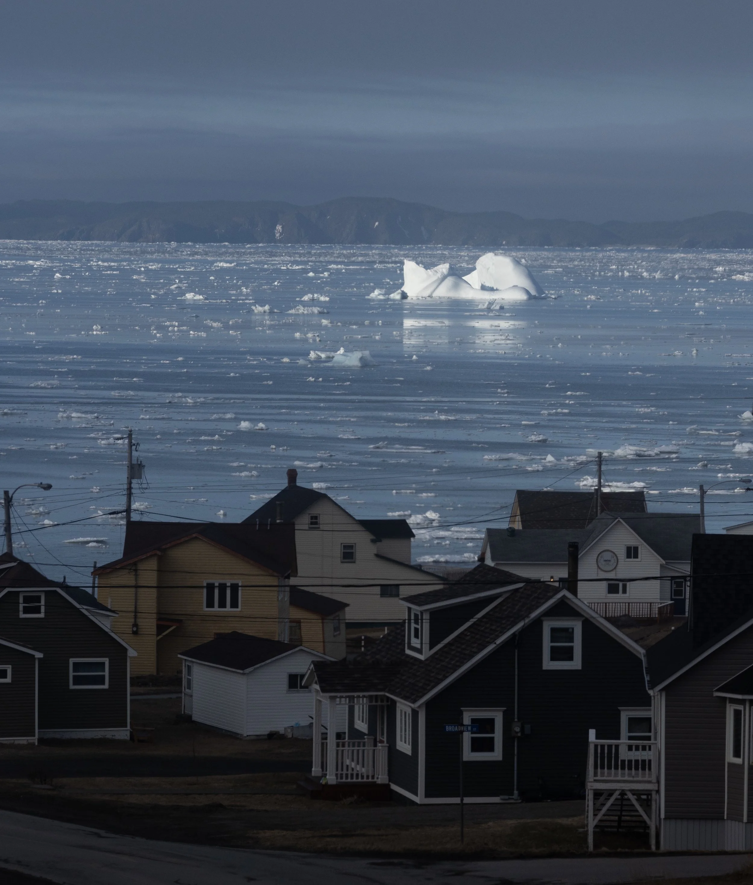
Luckily too; because this ended up being one of the best hostel experiences I have ever had. This was partly due to the hostel itself which was clean, well laid out with a nice kitchen, all the needed amenities like nearby groceries and laundry facilities in place, and a homey feel. Looking out the kitchen windows making dinner or a pot of tea one could watch the ice build up and pass through the harbor day-by-day. Iceberg ground zero.
But also this great experience was due to the small crowd of other guests, all of whom shared the same enthusiasm for getting out to see the big ice. Four women, and me; not too bad. Not bad at all.
The first thing to know about iceberg season is that there is a lot more ice out there than just bergs. While I had seen a great deal of sea ice on the cargo ship coming down the St Lawrence, see Côte-Nord, that was mostly from frozen over harbors and bays, relatively calm places.
What I came to understand in Twillingate was that sea ice formed in the mean streets of the Arctic Ocean and Labrador Sea was bigger, bluer, thicker and gnarlier by far. These slabs and chunks were sculpted by unimaginable pressures all Winter and then Spring-melted into beautiful, confounding, and improbable shapes.
And it was everywhere, getting into even the narrowest and most hidden away harbors and inlets. There came a point when, after seeing views like this consistently at every turn, I no longer stopped the car and got out to look and shoot photos. “Oh, well here’s just some more ice. Ok.” I knew this would be missed once I moved South and left it, but after awhile sensory overload just wouldn’t let me remain in perpetual wonder.
But the main attractions were the icebergs themselves. These were not just a single winter season old, but thousands of years. Compressed snow, not really flowing water frozen into ice exactly. Hard as nails, yet brittle. The last time the water contained in them was in liquid state all humans lived in hunter/gatherer societies. What can be seen above water is only 10% of the total mass, and though I’ve heard that statistic before and I have now seen them, I still cannot fully comprehend all that extra ice.
The shot below was taken with a telephoto lens and it has been severely cropped as well to blow it up further. These were a long ways away, out in the bay, as can be seen by the seemingly tiny boat to the right. That actually was a good sized fishing trawler. One of the hardest things about shooting icebergs is to put into the photo something to provide perspective as to how massive these are. Unfortunately there often aren’t handy kayakers paddling up next to them to give us a scale as to their true size.
Here is that same fishing vessel after it came in closer and passed by a considerably smaller berg that, due to its size, could get further up into the harbor. The biggest ones usually grounded in seas as much as 100 ft deep. They would say that it was grounded on a ledge, but we don’t often think of a ledge as being something that deep. When was the last time a ship struck a ledge 100 feet deep? They grounded on the bottom.
But eventually you need to get out on the water to see all of this up close for yourself.
My hostel-mates, Rita (from Calgary), Aude and Stephanie (college students from Quebec), Erin (from Ontario and embarked on her first of what will likely be many successful solo trips), and I were all looking forward to the next day when clear skies were forecasted. Rita had spent the day I had arrived out on a boat with “Skipper Jim,” which had been his first day out this season. So she and he had gone out alone in only a small boat, his larger one was not yet in the water. Based on her recommendation I called Skipper Jim and he said he would get back to me once he had the weather sized up. In the meantime Aude and Stephanie decided to join in. And then Rita figured she would go back on the water for another day before she had to head home.
So when I talked to Skipper Jim after the forecasts had been issued, we had become a party of 4. He would have to put his bigger boat in the water. Erin had decided to explore nearby Fogo Island for the day.
In the morning we drove down to the harbor facing the other way from our hostel and found the small pier in a tiny harbor which was roped off at the waterline to keep ice from coming in and crushing his dock. Skipper Jim was a bit concerned that a mass of sea ice had drifted into the bay that night, it was lined up in several deep masses or large concentrations. Though we might get to the icebergs out in open water, should the wind and tides conspire, the ice from two concentrated masses could combine around us or his little ice free harbor and we might not get back. As it grinds together the ice crowds in to the point where there isn’t enough water between floes to steer a boat through it. He said if that happens then bundle up because we would be stuck until the coast guard comes along and frees us. Ominously, no timetable for when that might happen was forthcoming. He didn’t say it might take a day or so, but he didn’t say it would be sooner either. Misplaced visions of Ernest Shackleton were swimming in my head. Pure excitement.
Still, after some hesitation Skipper Jim gave it a go. With a lot of weaving in and out of floes we did fine. And we eventually broke through a couple of dense packs of ice to open water and cruised out to this monster grounded well out in the bay.
It is hard to convey in photographs just how big these things are. I would say this one shown above covered something close to a football field, but frankly I might be doing it a grave injustice. Maybe it was two, or maybe more. It was hard to tell. Without something normal in the photograph, sitting right next to it, their massive scale is lost.
I recall taking the photograph below, using a wide angle lens that captured more area but sacrificed size perspective to do so. At one point I put the camera down. The difference in perspective was startling. What looked large, but within range of normal, inside the viewfinder, was in fact huge and tall. When I looked at the iceberg directly from this same vantage, I had to look not out horizontally, but up, about 45 degrees. We were quite close, so close nothing else would have been allowed any closer to help add perspective. (Getting too close is quite dangerous, they can roll unexpectedly and take someone down with it. So by regulation the tour operators can go no closer than the height of the tallest part, which makes this 45 degrees exactly.)
Taking shots of these was something for which I needed a lot of instruction. After a few days I still had a lot to learn. But one key is to somehow arrange a handy kayaker to get in between you and the berg to give an idea of scale. We didn’t have any of those around. (Had one been there they would have been about the height, or a little less, of the secondary water-line running parallel to and just above the water I think.)
And just when you think that what you are looking at is astounding, you go around to the side and see it’s just a small part of the whole thing.
As I mentioned, having the others in the hostel to share experiences, with tales told well into the evenings, made all of this more enjoyable by far. And we pointed each other in the right directions; “Head out to Toogood Arm and at the end of the peninsula (the Arm) on the left there is one close to shore.” (Newfoundland place names are priceless.)
That evening when Erin returned from Fogo Island we sat at the kitchen table, cradling hot tea mugs and shared each of our days’ activities and our photos. She had hiked a lot and also covered a good part of the island. Apparently, a Flat Earth society of some sort, with all the considerable scientific acumen available to their discipline, have earmarked a mountain on Fogo Island as one of the four corners of the Earth. She dutifully climbed it and returned alive. Her weather had been great like ours. And of course there had been ice.
I would head to Fogo Island the day after our boat ride. Erin and our adopted French college students were going kayaking, apparently Aude and Stephanie knew a lot of French Voyageur songs which they sang all day. Rita had headed home already, and Aude and Stephanie would also be moving on for other adventures after the kayaking song-fest.
I really enjoyed my ferry out to and drive around Fogo Island, but will reserve the photos from that side-trip for another post.
After returning from that long day, I walked into the hostel, peeled off layers of protective clothing and dropped my gear on a bunk in the dorm room. I heard Erin upstairs stir. When there were footsteps coming down the stairs, I went into the kitchen and put on the kettle for tea.
©️ 2019 D Abbott